
county building #2

FEMA releases new flood maps for Genesee County, hosts open house May 15

By Press Release

Press Release:

County, state, and federal officials are working to reduce the effects of severe weather and natural disasters. On March 3, FEMA released a preliminary Flood Insurance Rate Map (FIRM) for Genesee County for the public to see and comment on.

The new map gives updated information about the community’s flood risk. The map also shows areas where flood insurance coverage may be required. The current maps for Genesee County (paper, not digital) were developed in the 1980s. Some areas of the preliminary FIRM show major flood hazard changes compared to the maps that are in effect now.

FEMA, the New York State Department of Environmental Conservation, and Genesee County officials invite residents to learn how they may be affected and what they can do to protect themselves. 

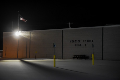
The Flood Risk and Insurance Open House will be held in person on Thursday, May 15, from 3 to 6:30 p.m. at Genesee County Building #2, 3837 West Main Street Road, Batavia.

The Open House will not have a formal presentation. Residents can join at any time between 3 and 6:30 p.m. They can stay for any length of time. At this event, residents can talk one-on-one with FEMA representatives. They can learn more about their flood risk and potential changes to their flood insurance rates and requirements. 

If you already have flood insurance, please bring a copy of your declaration page. Residents can also see preliminary versions of the FIRM and the Flood Insurance Study (FIS) report here. They can use the Old Paper Effective vs. New Digital Preliminary Data Viewer to compare the new preliminary map to the older maps.

The last FIRM for Genesee County was a paper map from the 1980s. The new FIRM will be online, which will make them accessible to more residents. It will also help community members think about how to protect themselves from future flood events. The map and the FIS report are the basis for each community’s floodplain management regulations.

Due to these map changes, some properties in Genesee County may no longer be shown in the high-risk flood zone. This is known as the Special Flood Hazard Area (SFHA). If a building is outside the SFHA on the new FIRM, flood insurance is not federally required. However, it is still recommended for both homeowners and renters.

Some properties may be shown in an SFHA for the first time. Those owners may need to buy flood insurance. Flooding is the number one natural disaster in the United States. Community members should know their current flood risk. This can help them use the tools and programs available to make their property and community safer.

Would you like to request a reasonable accommodation (sign language, real-time captioning or other)? Please email Michael.Foley3@fema.dhs.gov or FEMA-CivilRightsOffice@fema.dhs.gov. You may also call FEMA’s Civil Rights Resource Line at 833-285-7448.

To learn more or to see the flood maps, visit FEMA’s Flood Map Service Center at msc.fema.gov. At floodsmart.gov, you can learn about flood insurance. You may also contact a map specialist at the FEMA Mapping and Insurance eXchange (FMIX) at 877-336-2627 or FEMA-FMIX@fema.dhs.gov. 

For Open House questions, email our outreach lead, Rachel Wagner, at rachel.wagner@associates.fema.dhs.gov.

Genesee County land owners given to Feb. 24 for inclusion of agricultural land

By Press Release

Press Release:

From Jan. 26 to Feb. 24 a land owner may submit a request to include entire parcels of predominantly viable agricultural land within a certified New York State Agricultural District.

NYS Agricultural and Markets Law requires that the County Legislature designate an annual thirty-day time period within which a land owner may submit a request for inclusion of property within a certified agricultural district. 

This annual time occurs in Genesee County from Jan. 26 to Feb. 24 and is exclusively designed to incorporate property that is predominantly viable agricultural land – defined by Genesee County as lands that are composed of at least 51% prime farmland soils and/or are contiguous to the main farm operation.

Applications for the inclusion of land are available at the Genesee County Department of Planning in County Building No. 2 (3837 W Main Street Rd, Batavia) or can be downloaded or printed by visiting the website:

http://www.co.genesee.ny.us/departments/planning/agricultural_farmland_protection_board.php#annualenrollment

The application must be completed and signed by the landowner and returned to the Genesee County Department of Planning by 5 p.m. on Feb. 24. Due to the language of the NYS Agricultural and Markets Law, no applications can be accepted before Jan. 26.

PLEASE NOTE: Requesting enrollment of property during this thirty-day time period is not a guarantee that your property will be added to an existing Agricultural District, and it will not automatically qualify your property for a reduced agricultural property tax assessment. For information on obtaining a reduced agricultural property tax assessment, you must contact your local assessor. Please remember, that the Taxable Status Date is March 1.

Pipe bursts in County Building #2 during off hours, but damage reduced by timely discovery

By Howard B. Owens

County Building #2 got some water damage Monday, but the situation could have been worse if a member of the county's IT staff hadn't showed up for work that day -- President's Day -- to put in some overtime on a work project.

On a day of single-digit temperatures, a pipe froze and then burst, causing flooding throughout about 50 percent of the building.

If not for that employee, County Manager Jay Gsell said, the flooding wouldn't have been discovered until staff showed up for regular work hours on Tuesday morning.

The water spread through the building as just a thin layer, pooling in areas of floor depressions, and had to be squeegeed out. About 18 members of the Town of Batavia Fire Department turned out for the job.

Gsell said that volunteer effort was a big help in building cleanup.

However, there are storage shelves -- mostly belonging to history department -- with water still standing under them.

Highway Superintendent Tim Hens said contractors from ServePro will provide an estimate to finish the drying out process. He estimated the bid will be from $20,000 to $40,000 and he asked the Public Service Committee yesterday to authorize the contract on an emergency basis.

He expected the building's heaters to be running full force overnight to help dry out the building.

While no historical records or artifacts were damaged in the flooding, continued moisture is a threat to records and if it gets into the walls it could lead to mold and mildew problems.

There was flooding under the false floor in the county's server room, but all of the cables and connectors are encased in waterproof coverings so no equipment was damaged.

Photo: Antenna maintenance

By Howard B. Owens

Earlier today, antenna maintenance taking place at County Building #2 on West Main Street Road, Batavia.

Authentically Local