County, state, and federal officials are working to reduce the effects of severe weather and natural disasters. On March 3, FEMA released a preliminary Flood Insurance Rate Map (FIRM) for Genesee County for the public to see and comment on.
The new map gives updated information about the community’s flood risk. The map also shows areas where flood insurance coverage may be required. The current maps for Genesee County (paper, not digital) were developed in the 1980s. Some areas of the preliminary FIRM show major flood hazard changes compared to the maps that are in effect now.
FEMA, the New York State Department of Environmental Conservation, and Genesee County officials invite residents to learn how they may be affected and what they can do to protect themselves.
The Flood Risk and Insurance Open House will be held in person on Thursday, May 15, from 3 to 6:30 p.m. at Genesee County Building #2, 3837 West Main Street Road, Batavia.
The Open House will not have a formal presentation. Residents can join at any time between 3 and 6:30 p.m. They can stay for any length of time. At this event, residents can talk one-on-one with FEMA representatives. They can learn more about their flood risk and potential changes to their flood insurance rates and requirements.
If you already have flood insurance, please bring a copy of your declaration page. Residents can also see preliminary versions of the FIRM and the Flood Insurance Study (FIS) report here. They can use the Old Paper Effective vs. New Digital Preliminary Data Viewer to compare the new preliminary map to the older maps.
The last FIRM for Genesee County was a paper map from the 1980s. The new FIRM will be online, which will make them accessible to more residents. It will also help community members think about how to protect themselves from future flood events. The map and the FIS report are the basis for each community’s floodplain management regulations.
Due to these map changes, some properties in Genesee County may no longer be shown in the high-risk flood zone. This is known as the Special Flood Hazard Area (SFHA). If a building is outside the SFHA on the new FIRM, flood insurance is not federally required. However, it is still recommended for both homeowners and renters.
Some properties may be shown in an SFHA for the first time. Those owners may need to buy flood insurance. Flooding is the number one natural disaster in the United States. Community members should know their current flood risk. This can help them use the tools and programs available to make their property and community safer.
Would you like to request a reasonable accommodation (sign language, real-time captioning or other)? Please email Michael.Foley3@fema.dhs.gov or FEMA-CivilRightsOffice@fema.dhs.gov. You may also call FEMA’s Civil Rights Resource Line at 833-285-7448.
To learn more or to see the flood maps, visit FEMA’s Flood Map Service Center at msc.fema.gov. At floodsmart.gov, you can learn about flood insurance. You may also contact a map specialist at the FEMA Mapping and Insurance eXchange (FMIX) at 877-336-2627 or FEMA-FMIX@fema.dhs.gov.
For Open House questions, email our outreach lead, Rachel Wagner, at rachel.wagner@associates.fema.dhs.gov.
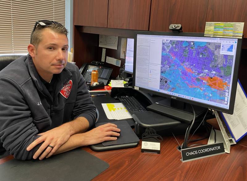
City of Batavia Fire Chief Josh Graham shows the newly configured flood map with a reduced floodway on the city's Southside. Photo by Joanne Beck
For as much detail as there’s been for newly configured flood maps in the city of Batavia, there are still unknowns that city officials want to get their hands on, City Manager Rachael Tabelski says.
One key detail is the list of structures being added to the 100-year floodplain. Out of the total 147 structures, “60 are potentially commercial,” which could have a huge impact on the city’s economic growth, Tabelski said during an interview with The Batavian.
She wanted to first define the difference between the city experiencing more frequent flash floods and more severe overflowing creek floods.
“Sometimes we have severe flash flooding that occurs where our storm system can't drain the water away quick enough, but then it goes down really quickly, totally separate from when the creek actually floods and goes above the banks of the creek,” Tabelski said. “And I'm just looking up some of the dates of the last flood. Since I've been manager, we have not had any creek flooding. So that's since I've been with the city, that's at least five years.
“And the maps were set in the 80s, and they were, I'll call them paper maps,” she said. “As a way they're doing it now, is with LiDAR, and that's electronic, and it takes a lot of measurements of cross sections of the creek every 1,000 feet. And then what their model does is try to predict where the water will move throughout the city, if it does press over the banks of the creek, and then that becomes your flood zone in the city.”
FEMA established a new floodplain map using the new technology and asked for feedback with a 30-day public comment period. Preliminary maps will be issued, and homeowners who would be affected will be invited to a presentation early next year to learn more and have the option to challenge the findings if they have been inserted into the flood plain.
“We also had our engineers get the baseline data from FEMA and make sure how their modeling was scientifically standard, which they agreed, but they had one finding that they believed that the floodway was too expansive and that they were asking in this draft round of proposals to reduce the floodway,” City Fire Chief Josh Graham said. “So the floodway is once you cross the banks of the waterway, that immediate area that will be flooded, I guess, that's the best way I can explain it. It's the area where the water flows in a flood. So this is what they have for the updated maps.”
So, what does this updated map signify to the city? “In terms of development in the city, it's much more difficult to get a building permit in a floodway than it is just in a flood zone, so it would hinder development efforts of any of the properties in the floodway, and that could be properties the city owns; commercial properties or residential for structures such as sheds, barns, things of that nature,” Tabelski said. “So the larger the floodway is, the more properties will have difficulty developing in any way, is one way I like to look at it from an economic development standpoint.”
When a property owner wants to get a permit for home renovations and lives in a flood zone,they would have to fill out a separate Department of Environmental Conservation permit application, she said. And there are other restrictions for commercial buildings that aren’t compliant or don’t have flood insurance — they can only invest 49% of their building’s value, either by an independent appraisal or their assessed value, she said.
“So I find this a critical issue for our businesses on Route 63 and our buildings. I mean, on Route 63, who the majority of them are in the flood zone, and when they want to make investments, they can be hindered by higher costs to become flood compliant, to be insured or to only invest up to 49% of their appraised value of their building,” she said. “And we've seen that a lot on the economic development side successfully. It has been done by Stephen Valle and his sister Carrie, with the building on the corner that houses the vegan bakery and apartments upstairs, so they were able to get an appraisal and invest in the building after that appraisal, but they are in a flood zone.”
For homeowners and renters, being added to the flood zone signals the push for buying flood insurance to ensure coverage in the event of damage from a flood, since regular insurance doesn’t usually cover that type of damage; and it serves as caution for when people are considering a construction project, since the city has an ordinance covering development in the floodplain or flood hazard area.
Other challenges exist for commercial property owners, such as the inability to invest more than 49% of the property’s assessed value. So, for 60 additional commercial properties, that’s a potential problem, she said.
Properties that are and were in the 500-year flood plain did not have to buy flood insurance, and while those 147 structures are moving into the 100-year flood plain, another 282 are being removed since the map has been recalculated.
“Under the new draft, there’ll be 917, so we end up losing 135 structures,” Graham said. “At the end of the day, there’s going to be 135 less structures in the flood zones than there are right now, 282 that will no longer be identified, but 147 new ones that will be.”
How did that happen? An electronic survey was done using LiDAR technology, a remote sensing method that uses light to measure ranges and map out the flood zone every 1,000 feet, predicting where water will move within the city, he said. That reconfigured the original number of 1,052 people and reduced the total to 917 by shifting—and reducing the footprint—of the overall floodway.
The flood zone is predominantly on the south side, with the largest flooding happening on Law and Walnut streets in recent years. If you live on the South Side, you may be, or want to become, familiar with a few common acronyms that might come in handy when dealing with flood zones and flood plains:
Property owners can challenge a finding by paying for a survey to determine if they live on a higher elevation than previously established. This is called a LOMA — a letter of map amendment — and the process will involve the Federal Emergency Management Agency (FEMA).
Does that mean they will no longer need flood insurance if they were required to have it while classified in a flood zone? “If your property is no longer in a flood zone, you can drop insurance with proper documentation from FEMA,” Tabelski said.“So there is a process that those properties will have to take. And that’s why, when we have FEMA host these preliminary meetings, we’ll be inviting anyone in the areas of the flood zone area, the new ones that are coming in will have to be educated now that they’re in a flood zone, and they can … go through that process, and when theproperty sells, it is my understanding if you have a mortgage on it, you’re going to need that flood insurance.”
They want city property owners to know that not only will FEMA be on hand during a meeting in early 2025 to work with folks and answer questions, but city officials also want to help out.
“Nothing's final, but there are changes coming,” Tabelski said. “You'll be getting some hands-on assistance early next year straight from FEMA, absolutely, and we'll do our best to interpret it and be the go-between and be as informed as we can to help residents.”
Batavia Development Corporation, which established the real estate company Creek Side Batavia, LLC, has put the sale of the property behind the McCarthy ice rink and along Tonawanda Creek on hold due to this change of floodway.
The City of Batavia has received notification from FEMA’s NFIP/CRS program that it has met the recertification requirements for its continued participation in the Community Rating System (CRS). According to Fire Chief and CRS coordinator Stefano Napolitano, the City will maintain its current Level 7 rating.
This rating will enable those residents and business owners in the City's Special Flood Hazard Area (SFHA) to continue to receive 15-percent discounts on their flood insurance premiums, while those outside the SFHA will receive an additional 5-percent discount on top of already reduced rates.
In addition to the financial benefit, the CRS aids in improving community flood mitigation efforts.
These include: better informed citizens; enhanced public safety, reducing potential damage to property and public infrastructure; avoidance of economic disruption; and protection of the environment. In addition, implementing some CRS activities, such as floodplain management planning can assist a community qualify for certain Federal assistance programs.
This recertification maintains the groundwork previously laid out by City management and continues to be an integral part of the City’s comprehensive strategy to improve neighborhoods and the value of City properties.
Chief Napolitano acknowledged that there was a tremendous amount of work to recertify and maintain the Level 7 rating and he wanted to acknowledge the efforts of all members of the CRS recertification team, which included himself along with, Fire Department Capt. Bob Fix, Floodplain Manager Ron Panek, Inspection Bureau secretary Meg Chilano and confidential secretary Lisa Casey. Napolitano also wanted to acknowledge Erin Pence from the Genesee County Planning Department, who assisted the recertification process with mapping services.
Eugene Jankowski Jr., Council president, said, “I would like to acknowledge a job well done to Fire Chief Napolitano and his team. The CRS recertification is a critical component to manage the high cost of flood insurance for our residents in the flood zone."
Lastly, Napolitano points out that the annual CRS recertification process is an ongoing and continual one. Throughout the year, there will be activities which are vital to maintaining the City's current level, but also involve researching the readiness and ability to move beyond a Level 7.