
snow

Photos: Snow blowing off the roof of the former Kmart building in Batavia

By Howard B. Owens
WEATHER PHOTO kmart
Snow blowing off the roof of the former Kmart building late Wednesday afternoon as seen from the parking lot of Batavia Downs.
Photo by Howard Owens.

A heavy snow squall bulletin has been issued for northeastern Genesee County. The warning is in place until 7 p.m. Wednesday.

Parts of Genesee County could also receive heavy snow with blowing wind Wednesday evening.

There's also snow in the forecast for Friday and Saturday, with a low temperature on Sunday, which is estimated at 14 degrees.

snow blowing off kmart building
Snow blowing off the roof of the former Kmart building late Wednesday afternoon as seen from the parking lot of Batavia Downs.
Photo by Howard Owens.

Photos: Batavia gets busy digging out from overnight snow

By Howard B. Owens

snowdaymlk2022a.jpg

While much of Batavia was busy this morning digging out from more than a foot of snow that fell overnight, Grayson, 3, and Deliah, 5, found it was a good time to play outside their home on Hart Street.

snowdaymlk2022-2.jpg

Jackson Street

snowdaymlk2022-3.jpg

Morton Avenue

snowdaymlk2022-4.jpg

Center Street

snowdaymlk2022-5.jpg

Center Street parking lot

snowdaymlk2022-6.jpg

Summit Street

snowdaymlk2022-7.jpg

City Hall

snowdaymlk2022-8.jpg

State Street

snowdaymlk2022-9.jpg

State Street

Afternoon of snowmen building

By Steve Ognibene

a76y8730.jpg

The George family siblings worked on building some snowmen with their grandmother yesterday afternoon before the warmer temperatures came in today. It was good packing snow and they wanted to take advantage of having some outdoor fun while we still had some snow.

Batavia residents keep up with another day of heavy snowfall

By Alecia Kaus

Redfield Parkway about 11:30 this morning. The winter storm warning is in effect until 10 p.m. Another 3-6 inches of new snow is possible tonight.

Washington Avenue bus stop. At 3 p.m. heavy snow made driving a little difficult.

Redfield Parkway resident Bob Johnson uses the snowblower to keep up with the heavy snowfall.

Guillermo Leon did not seem to mind shoveling his sidewalk on Richmond Avenue.

He says he likes winter.

Karen Baker clears off her car after picking up her two sons Michael and Justin from school.

City Plow making the rounds.

A morning of digging out

By Alecia Kaus

Ellicott Avenue snow


Many residents could be found digging out their driveways and clearing their cars of snow this morning.

After five straight days of snowfall, Genesee County will be getting a break today. There are no warnings, watches or advisories and temperatures will rise to the mid-20s. There is a chance of snow, but less than a half inch.

The seven-day forecast calls for rising temperatures and possibly 45 degrees by Friday.

Greg Lee uses his snowblower to clear his rental property on Richmond Avenue.

Pat Cavanaugh shovels out her driveway on Redfield Parkway.

Pat's neighbor gives her a hand.

After many days with temperatures below freezing, icicles have formed on Arby's front windows.

The McFollins brothers tried to go sledding at Centennial Park, but the snow was not good for sledding. So a snowball fight broke out on the way home. Pictured are Javin, 8, Ayden, 10, Mason, 12, and Carter, 8, of Batavia.

Plows were out clearing and salting the roads and streets seemed to be in better shape than yesterday.

Heavy lake effect snow will continue and then move south

By Alecia Kaus


The National Weather Service out of Buffalo says the heavy lake effect snow hitting Genesee County will stay over the area for at least another hour.

The band will then move south and into Wyoming County and the Southtowns.

There have been several property damage accidents throughout the county, but motorists seem to be taking it slow on the drive home tonight.

Snow Rooster

By Susan Brownell

Well, here at my house, we don't usually make the average snowman. 

Today, we made a snow rooster. 


Road Conditions

By William Buckley

UPDATE 8:20 AM:
All road segments mentioned below plowed and passable now, though E/W Saile is still somewhat slick as of about 7:15. Some lanes are not fully cleared yet, but there is a clear path of travel in both directions.

Road Conditions as of 6:00 AM:
Main St. From Tops (5/63 Split) to Aldi (5/33 Split): Passable, was able to maintain speed limit.

63 from Main to Oakfield: "Snowball's Chance," slick, could not safely exceed 35 in 55 zone, TBFD called out to 8100 block (My-T Acres area) for vehicle off the road into the South/West tree line.

Hawley (GCC): "Snowball's Chance," in some spots even 25 did not seem to be a safe speed, unplowed as of 4:50. Eastbound appears to have been cleared now.

33 from Main to Batavia Stafford Townline/Seven Springs: Passable, cautiously.

E & W Saile Dr. (Airport) : Again, "Snowball's Chance," highly variable condition, slick, unplowed as of 5:00.

98 from W Saile to Thruway Entrance: Could not safely exceed 40.

Edit Notes:
8:20 AM - Added updated conditions, fixed Hawley direction described earlier, I lost my sense of direction.

Snow in LeRoy on April 7, 2009

By Howard B. Owens

I stopped in LeRoy today and spotted this scene and snapped a quick pic -- snow in LeRoy in April.

Snow advisory through this evening

By Philip Anselmo

We could see as much as five inches pile up by dinner time tonight. The National Weather Service out of Buffalo has issued a lake effect snow advisory for the region until 6 o'clock this evening. From the advisory:

Bands of lake effect snow will persist through the day. New accumulations in the most persistent bands will be in the 3 to 5 inch range. Brisk west to northwest winds will also lead to areas of blowing snow and poor visibilities.

In lake effect snow, the weather can vary from locally heavy snow in narrow bands to clear skies just a few miles away. If you will be travelling across the region be prepared for rapid changes in road and visibility conditions.

There's not much to see out on the radar so far.

However, things look a little greasy out on the Thruway.

Road conditions deteriorate quickly in Genesee County and environs

By Philip Anselmo

Roads around Genesee County are getting ever worse throughout the day today. Snow and rain have added to the already bloated mix of melted ice and snow from yesterday. Some roads are barely navigable at this time. Add to that the winds that are bringing down power lines across the region, and you've got a messy situation out there.

In the past half hour, we've heard of two reports of downed wires over the scanner.

Poles and wires have come down on Molasses Hill Road near Chaddock Road in Alexander. Another pole along with wires are blocking a roadway in Attica. We haven't yet got the report on that exact location, but crews are out trying to get things cleaned up as quickly as possible.

Conditions are even worse in Wyoming County, where the winds are whipping even more fiercely. Dan Fischer reports that the office of emergency management there has put out a general travel advisory for motorists. It reads: "Caution should be used when traveling in Wyoming Co. due to damage from high winds including downed utility poles and power lines. Be prepared to seek alternate routes as some roads have been closed due to blockage."

You can find out more on area closings by visiting the WBTA Web site.

All around nasty weather throughout the day throughout the region

By Philip Anselmo

We're in for an ugly cocktail of dangerous weather today. Right now, Batavia is under three separate warnings, issued by the National Weather Service. Ice floes and warm temperatures look to flood the Tonwanda Creek. Winds of sustained gusts at 40 mph are whipping up to 70 mph at times. And, just for good measure, we've got a snow storm.

On the flood:

The flood warning continues for the Tonawanda Creek at Batavia from this morning to tonight. At 5:00 a.m. Thursday the stage was 72 feet and rising. Minor flooding is forecast. Flood stage is 9.0 feet... The river is expected to rise above flood stage late this morning and crest near 9.2 feet this afternoon.... At the 9.0 flood stage: Flood protection at Chestnut Street Bridge begins to be toppd. There is also flooding in Kibbe Park area of Batavia.

On the wind:

Deep low pressure will pass by to our north today. Southwest winds of 30 to 40 mph will gust as high as 70 mph during the day today. The powerful winds will become more westerly this afternoon then will gradually diminish tonight.

Shallow rooted trees, namely pines, will be especially vulnerable in this event as their shallow root system has become less stable with the thawing of the previously frozen ground. The added weight from several inches of wind blown wet snow will likely increase the potential for some downed tree limbs and power lines.

On the snow:

A winter weather advisory remains in effect until 6:00 p.m. this afternoon.

Cold, moist air filtering in behind a departing low will bring 2 to 4 inches of snow to the area today. Another 1 to 3 inches is expected tonight. Strong winds will add to the problems and generate very poor visibility at times and make it difficult to keep roadways clear.

Things do not look pretty out at the Thruway right now. Please be safe.

Snowman stands proud on Main Street Batavia

By Philip Anselmo

We spied this snowman built up out front of T-shirts Etc. on Main Street Batavia earlier today and thought to take a photo.

Let's call this a challenge to all Main Street merchants. Bring out your snowmen!

Snow mounds in Batavia growing tall

By Philip Anselmo

Driving along Main Street this afternoon, it dawned on me that I couldn't see some of the shopping plazas I normally pass by on my drive between Clinton Street Road and Center Street. Well, they were still there, only they were blocked by the mounds of snow like walls stacked high at the front of the parking lots. Down near Masse Place, in fact, you can't see any of the shops from the street. This is all you're going to see:

So this got me wondering: Where's the tallest snow mound in Batavia? This one looks like it could fit the bill, but I haven't been everywhere.

Walking around the city during the storm

By Brian Hillabush

After getting caught in the snow four times during our last blizzard, I figured driving was not an option. Who in their right mind is going to drive around in this?

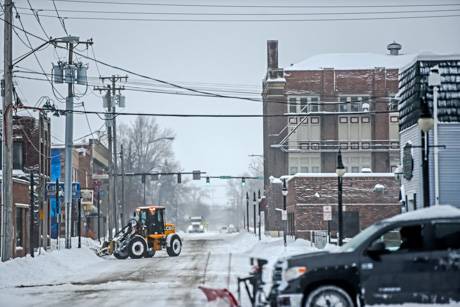
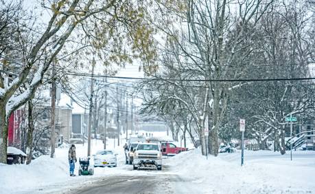
Apparently a lot of people are doing just that as Main St. had its usual mid-day traffic and was cleaned up for the most part.

Well I decided to get all bundled up and go for a walk. Dumb idea.

I took a trip around my part of the city, walking around two different blocks, and it was brutal. The weather is 32-degrees right now, so it wasn't the cold that was the problem. It was the snow coming down in such a burdensome manner. 

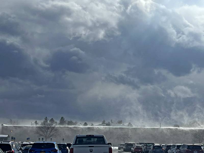
I'm guessing that if you get outside of the city and are driving on Rt. 63 or 19, you are in for a lot of whiteout conditions as there is a slight wind in the city, which means when you get out you are in trouble.

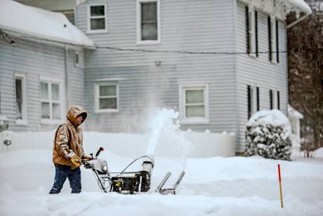
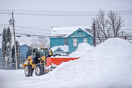
This isn't that light snow that is nice to see once in a while. This is the big flake, heavy, pain in the butt type of snow.  I am so happy that my neighbor has a big snow plow and is a good guy or I would be in trouble today. I still can't lift heavy stuff after the carpal tunnel surgeries over the summer and I have a feeling that it would kill me to have to clear that stuff out on my own.

So I noticed a few things on my walk. First is that moving during the winter sucks. I found a guy moving in on Montclair Ave. and let's just say these aren't the ideal conditions. 

In fact, he tried to move the moving truck so that the plow could get down the street, and the battery had died. He found somebody and was getting a jump as I decided to head towards Main St.

I understand the sidewalks on the side streets being bad because people are at work. I just walked down the road. But I watched the mail carrier walking through big piles of snow and struggling just to get to people's mail boxes.

And then I got to Main St. and the sidewalks were just as bad.

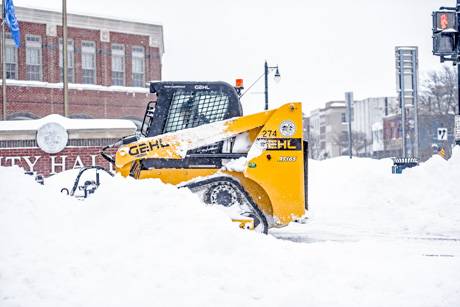
I made a left and walked towards Burger King and Arby's - which were both pretty slow for a mid-afternoon on a work day - and the sidewalks were clear in some places and not even touched in others. I thought the city owned some big machine that is supposed to drive around and clear of sidewalks?

How about getting that thing out on Main St.

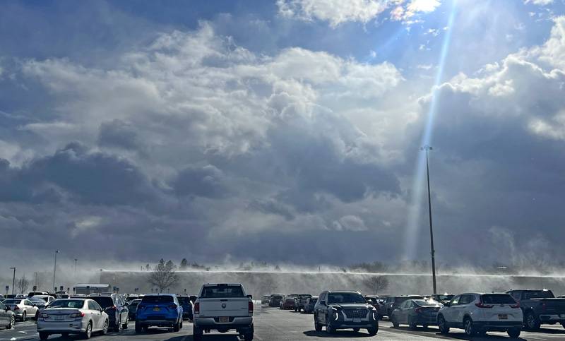
I could hear the speaker at Ken Barrett's  calling for service, but none of the cars were cleared off and nobody was shopping for a car. I get it. There is no way to get a feel for a vehicle when you can't drive faster than like 15 miles per hour.

I really was surprised at the amount of people out there driving because it is nasty out and probably will be for the rest of the afternoon. 

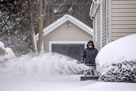
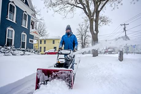
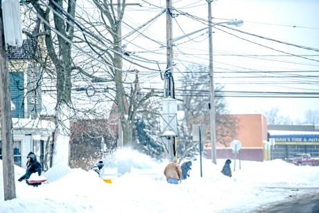
I saw a few people out shoveling and plowing driveways, but most of those that work during the day looked like they went in because driveways were packed all over the place.

As I was walking down Oak St., I saw a guy riding a bicycle down the road. He wasn't moving very fast and I can't imagine it was a pleasurable trip. I've never understood those that ride bikes when the weather is like this.

Finally I got home. What would usually be a 45 minute trip around a couple blocks took nearly and hour and half, but I did stop and talk to a few folks out there clearing their driveways and walking places.

The most common complaint I heard was the lack of cleared out sidewalks. If anybody knows about how the city handles sidewalks, I'd love to hear it.

I finally got home and was able to sit down at my computer, after a change of clothing because I looked like a snowman.

Winter storm warning remains in effect until 11 o'clock tonight

By Philip Anselmo

Snowfall has gained some force over the past hour here in downtown Batavia. The flakes are bigger, there are more of them and they're falling faster.

A winter storm warning issued by the National Weather Service out of Buffalo will remain in effect until about 11 o'clock tonight, although this should be the worst of it.

Moderate to heavy snow will bring difficult travel to western New York through this evening. Steady snow will continue today into early this evening before tapering off later this evening.

Snowfall rates may reach around 1 inch per hour during bursts of heavier snowfall today. Storm total accumulations are expected to reach 8 to 10 inches by late this evening.

Here's a look at conditions on Main Street in Batavia, outside our office. This video was taken shortly before 11 o'clock this morning.

Snowfall should turn heavy later this morning, another six inches likely

By Philip Anselmo

We're in the midst of it, now. It looks like we've so far collected maybe a couple inches of snow overnight, but this storms system has us blanketed like a croissant around a cocktail weiner.

Most meteorologists tell us that the worst is yet to come. Expect the snow to turn heavy later this morning, after 9 o'clock, and remain so right up through the afternoon. We do not yet have word of any school closures in the area.

Right now... it doesn't look too bad. It doesn't look fun, but not like anything we haven't tackled before. Here's how things stand on the Thruway at the Batavia exit. Please take it slow out there.

Storm watch upgraded to warning: Heavy snow overnight, into morning

By Philip Anselmo

Most of the folks who have taken our poll so far today are in agreement that "maybe" we will get a couple inches of snow overnight tonight. In fact, it's an overwhelming 76 percent of poll-takers who feel that way right now. That "maybe" attitude may change a little bit, however. The National Weather Service has upgraded their winter storm watch to a warning, and it sounds like we could get "slammed" over the next 24 hours.

The warning goes into effect tonight at 11:00pm, through to 11:00pm Wednesday night, although it sounds like overnight and tomorrow morning will be the worst of it. So plan for a tricky commute. Here are the details:

Moderate to heavy snow will bring difficult travel to the western New York tonight through Wednesday evening. Snow is expected to overspread the region by around or shortly after midnight, with periods of snow continuing through Wednesday evening. The snow may be heavy at times, especially late tonight and Wednesday morning.

Storm total accumulations are expected to reach 8 to 10 inches by late Wednesday evening.

Poll: Will we get hit with a big snow storm tonight

By Philip Anselmo

Meteorologists are holding true to their winter storm watch, still expecting the massive system now sweeping up from Ohio to hit hard tonight—check out our post from this morning. Although, initial predictions of up to a foot of snow for the region have already been eased. We're know expecting between five and eight inches of snowfall. Still, looking at this thing, there seems a chance that it could just sail right by us, never lifting north enough to cause any damage.

Last year, if I remember correctly, there were about a half dozen "major" snow storms that were predicted that never came to pass. Are we looking at another flop, or should be all be picking up our shovels?

Will we get hit with a big snow storm tonight?
( polls)

Storm watch says significant snowfall still likely tonight into tomorrow

By Philip Anselmo

A winter storm watch first issued yesterday evening is still in effect for tonight and tomorrow. Initial predictions were between 6 to 12 inches of snowfall.

From the National Weather Service out of Buffalo:

A storm system tracking northeast from the southern plains could bring a significant general snowfall to the area tonight and Wednesday. Some uncertainty still exists on the exact path the storm system will take, and therefore the amount of snowfall which may occur. Probabilities remain high enough that significant snowfall may occur to maintain the winter storm watch.

Again, here's a look at this storm right now. As you can easily see: it's enormous, stretching from Dallas to Philadelphia. It looks as if the real threat is the mass of snow currently creeping up through Ohio. Maybe we'll get lucky, and it will drift on by south of us.

Authentically Local